HYDROGEOLOGIC FRAMEWORK OF LONG ISLAND
Nassau and Suffolk Counties with close to 3 million people are completely dependent on groundwater for all of their freshwater needs. As a result the hydrology of Long Island has been extensively studied. Long Island is completely surrounded by salt water. New York City derives its water from upstate, but the supply is just adequate to provide the needs of the city. Thus the only source of fresh water on Long Island now or in the future is precipitation that becomes part of the groundwater system. Luckily an adequate supply of high quality freshwater is available if Long Island properly manages its water.
Geographic Features
The topography of Long Island is related to the last ice age, which ended ~ 10,000 years ago. The most prominent physiographic features are (1) the east-trending hills in the northern and central parts of the island, and their eastward extensions which form the "Forks," (2) the gently sloping plain that extends southward from the hills, (3) the deeply eroded headlands along the north shore, and (4) the barrier beaches along the south shore.
The two lines of hills (terminal moraines) which reach a maximum altitude of ~ 400’, are separate and distinct in the central and eastern parts of the island, but they converge in the western part. The southernmost line of hills (Ronkonkoma moraine) extends eastward to form the South Fork. The northern line (Harbor Hill moraine) extends eastward to form the North Fork. The moderately flat surface that extends southward from the Ronkonkoma moraine to the south shore is a glacial-outwash plain. The eroded headlands along the north shore are composed mainly of glacial deposits. Wave erosion has steepened the northern slopes of the headlands into nearly vertical bluffs that, in places, are ~ 100’ high. Along the south shore, waves and ocean currents have formed offshore bars, or "barrier beaches."
Major Hydrogeologic Units
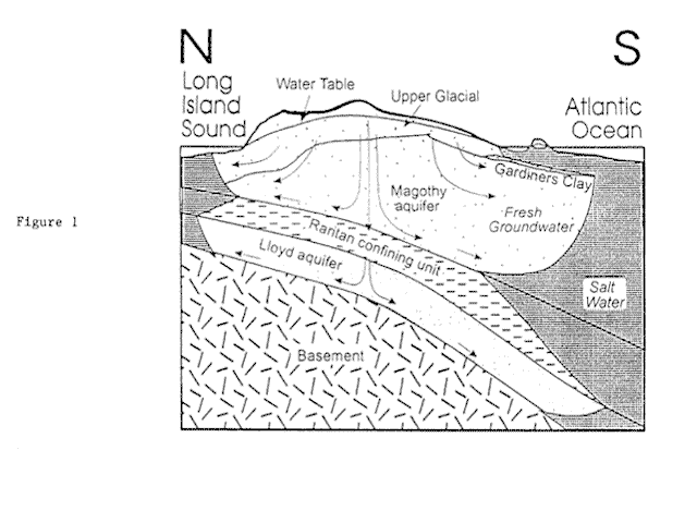
The unconsolidated materials that overlie the bedrock constitute Long Island ’s groundwater reservoir. These materials can be classified into several hydrogeologic units on the basis of hydrologic properties summarized in the following table. Three major aquifers can be identified: an Upper Glacial aquifer at the top, the Magothy aquifer in the middle and a deep less accessible Lloyd aquifer lying just above the Paleozoic metamorphic basement rocks. There are two major confining units. The Pleistocene Gardiners Clay is found mainly on the southern part of the island and provides some restriction of flow between the Upper Glacial and the Magothy aquifers. The other confining unit is the Raritan confining unit which is quite thick and restricts the flow between the Lloyd and the Magothy aquifers (Figure 1).
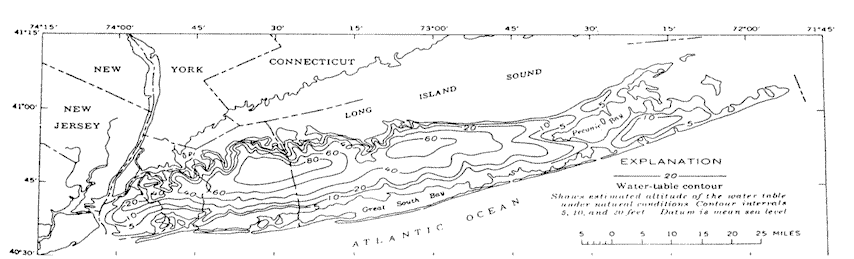
The boundaries of the fresh groundwater reservoir are the water table, the fresh-salt water interface, and the bedrock surface. The estimated average position of the water table under natural conditions is shown in Figure 2. It should be noted that since recharge occurs throughout virtually all of Long Island, the water table represents a dynamic boundary. The height of the water table and the location of the interface between the freshwater and saltwater at depth are transient and are affected by the extent of pumping and rainfall. The reservoir is bounded laterally by a second dynamic boundary - the fresh-salt water interface. Fresh groundwater can be found in the Lloyd aquifer below salty groundwater in the lower part of the Magothy aquifer (Figure 1). On the other hand, fresh water beneath the Forks of Long Island occurs in a relatively thin lens of thickness ranging from a few feet to several hundred feet. Both the Lloyd aquifer and the deep Magothy aquifer are saturated with salty groundwater beneath the Forks.
Surface Hydrology
Under natural conditions, precipitation is the source of all the fresh water on Long Island - that is, it is the total input to the hydrologic system. Long Island receives on average 44" of rain, or its equivalent in snow, per year distributed equally throughout the year (~ 3"- 4" per month). During the winter, most of the precipitation is derived from regional storms. In the summer, however, most of the precipitation is associated with local thunderstorms. As indicated in Table 2, average warm-season precipitation and cool-season precipitation are almost equal on Lond Island. Data from Setauket, the station with the longest period of record, indicate that precipitation on Long Island ranges widely from month to month and from year to year. The average annual snowfall on Long Island is ~ 25"-30", or ~ 10-15% of the water equivalent of the cool-season precipitation.
Precipitation on the land surfaces follows three primary paths - direct runoff (primarily streamflow), evapotranspiration, and infiltration into the unsaturated zone. The infiltrated water may either transpired by plants or percolate downward to the saturated zone. It has been estimated that under natural conditions an average of < 5% of total measured streamflow is direct runoff. This corresponds to < 1% of the precipitation that fell on the drainage areas of the streams. Approximately 50% of the precipitation is returned to the atmosphere as evapotranspiration (Table 3). This includes evaporation from the land surface and surface-water bodies, evapotranspiration from the unsaturated zone, and evapotranspiration directly from the groundwater reservoir. The upper limit of annual "potential" evapotranspiration for a specific year is probably on the order of 30" - 35".
Under natural conditions, virtually all groundwater recharge on Long Island resulted from the infiltration of precipitation into the vadose zone and subsequent downward percolation through the water table into the saturated zone. The average annual recharge has been estimated to be about one-half the average annual precipitation (~ 22"-23" of water), or about 1,000,000 gallons per day per square mile (Table 3).
The underground water is discharged from the aquifers by three primary processes: seepage to streams and springs, subsurface outfow, and groundwater evapotranspiration. As indicated in the above table, the evapotranspiration component is relatively small. A significant portion of the underground water is discharged through subsurface outflow, which is partitioned among the three major aquifers (with ~38% from Upper glacial, ~53% from Magothy, and ~9% from Lloyd.) Most streams on Long Island are effluent, that is they are fed by groundwater. The average flows of major streams on Long Island are compiled in Table 4. It has been estimated that seepage from underground aquifers contributes 90-95% of the total average streamflow (Table 3).
Groundwater Hydrology
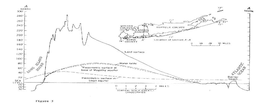
Precipitation enters the groundwater system by infiltration through the porous soil at Long Island’s surface. The field capacity of soils in the unsaturated zone is ~ 10-15%, and since the total porosity of the capillary fringe is ~ 30-35%, the specific yield of these materials is estimated to be on the order of 15-25%. A relatively high percentage of wet precipitation can percolate through the water table into the saturated zone. Figure 3 shows profiles of hydraulic heads in the major aquifers. A relatively small head difference occurs between the water table and the base of the Magothy aquifer. On the other hand, significant head loss exists between the base of the Magothy and the Lloyd aquifers, a consequence of the low conductivity of the intervening Raritan clay. Upward components of flow exist near the bottom of the Magothy and Lloyd aquifers in seaward directions near the intersections of the piezometric surfaces and water table.
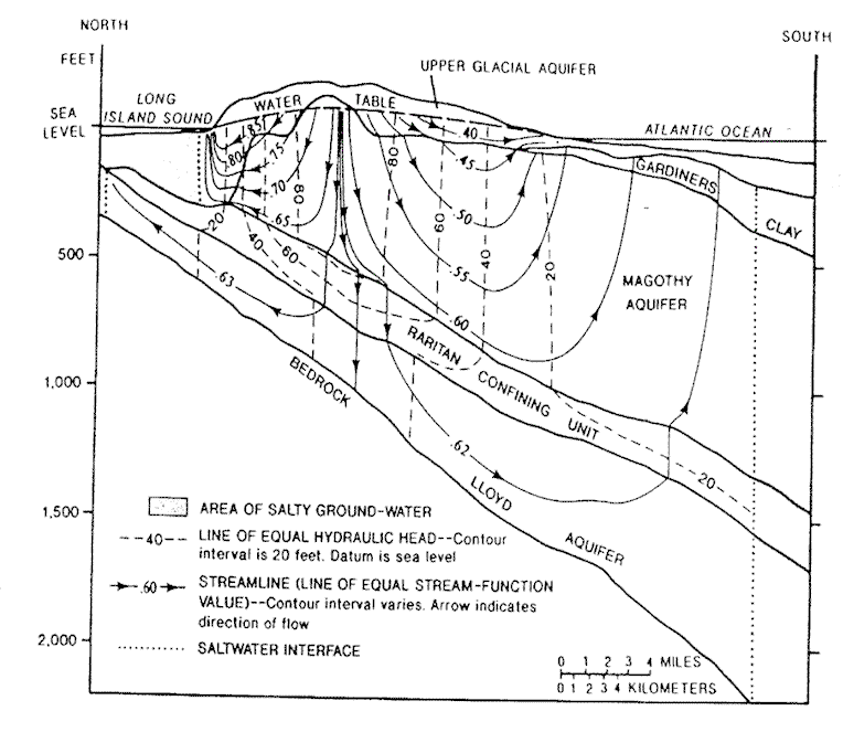
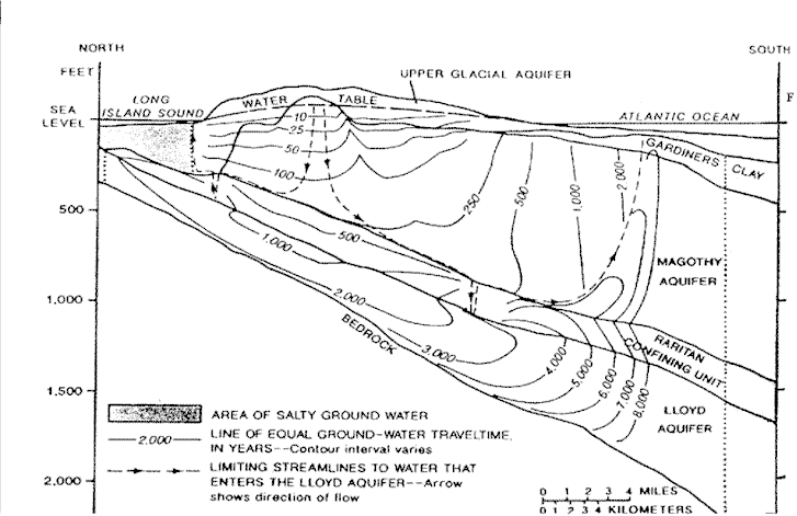
The groundwater flow has vertical and horizontal velocity components. To simulate the flow, realistic estimates of the vertical and horizontal conductivities are required. Table 5 compiles conductivity values (inferred from pumping tests) which were adopted in a recent USGS study. The simulated groundwater flow and travel time are shown in Figure 4. This type of groundwater model will be discussed in some details later in this course.
The flow of water is dominantly to the north or to the south of the ground water divide along the center of the island west of William Floyd Highway. Therefore there is little east-west mixing of the groundwater. East of William Floyd Highway there is significant flow eastward associated with the Peconic River. The water moves laterally in the Upper Glacial aquifer to streams and shoreline or moves downward through the Upper Glacial aquifer to the lower units. Some of the water from the Magothy circulates downward and then flows upward toward the shoreline and then into the Long Island Sound or Atlantic Ocean. The rest mixes at depth with salt water under the Long Island Sound and Atlantic Ocean. A very small percentage of the water penetrates the Raritan confining unit and enters the Lloyd aquifer (Figure 4a).
At the top of the Magothy the water is about 10 years old. Near the center of the Magothy it is 100 years old. Near the base of the Magothy the water is some 500 years old. The Magothy is the source of much of our drinking water. Within the Lloyd aquifer the water is much more ancient. Near the top the water is 1000 years old and as the freshwater-saltwater interface it is approached beneath the Atlantic Ocean the water is some 8000 years old (Figure 4b).
Water Quality and Groundwater Contamination
The Long Island water is quite pure with about 50 mg/liter, 50 ppm, of total dissolved solids, TDS. The water is, however, quite acid with a pH of 4.4 to 6.1, similar to that of the precipitation. As a result the water is quite corrosive. Due to the inert character of the minerals making up the aquifer, dominantly quartz sand, neither the concentration of TDS nor pH changes appreciably as the water travels through the aquifers.
What affects the pattern and quantity of water that enters the system? Paving of recharge areas and pumping. In Nassau and Suffolk Counties there is an extensive system of recharge basins that collect water from storm sewers and recharge the system. Water is withdrawn through some 1000 wells for public supply, irrigation, commercial and industrial uses. We then redeposit some of this withdrawn water through septic tanks. Where there are sewers little of the water is returned to the system. With irrigation a high percentage of the water is lost through evapotranspiration. During the 1980’s wells pumped 366 millions gallons per day (mgd) for public supply, 41 mgd for industrial and agricultural use, there was a loss of an additional 81 mgd due to increased runoff associated with development. Of the 489 mgd removed from the system, 249 mgd were returned to the system, for a net loss to the aquifer of 240 mgd.
The result of this excess withdrawal has been shrinkage of the freshwater bubble. This has resulted in:
- saltwater incursion near the Nassau-Queens border,
- reduction of the height of the water table in Jamaica to below sea level,
- reduction of the height of the water table by some 20 feet in Nassau County,
- the subsequent drying up of streams and lakes in Nassau County, and
- the reduction of the height of the water table in Suffolk County by at most a few feet.
Nassau and Suffolk counties share the same aquifers but have different problems associated with the differences in population densities and times of development of the two counties.
Nassau County
Nassau County presently has a population of some 1.3 million people and an area of about 300 square miles. Precipitation provides 660 mgd of which 315 mgd is lost to evapotranspiration and 15 mgd to direct runoff. Recharge into the groundwater system is 330 mgd. 180 mgd is pumped from the groundwater system, 40 is discharged through effluent streams, and 110 mgd is discharged underground. Consumptive use amounts to 180 mgd of which 140 mgd is lost through the sewer system, 34 mgd through sprinkling and 6 mgd through industrial-commercial use. Earlier when there was a projected population of 2.3 million people it was feared that Nassau County would not have enough water to serve its population. Nassau County did feasibility studies showing that it could take waste water, treat it and then recharge the aquifer. However, this would be very expensive and is now thought not necessary. This is because the population has stabilized or is decreasing and water conservation has reduced water use. There was also a concern that salt water incursion would become a serious issue. This incursion appears to have stabilized and is a problem in only a few areas. The reasons for salt water incursion near Great Neck and along the south shore include the effects of pumping and the continuous sea level rise of about one foot per century. Limits on the amount of water that can be pumped (caps) have been placed by New York State DEC in response to problems of saltwater incursion and the drying up of streams and lakes. Presently over 90% of Nassau County is served by sewers. Essentially 100% of the water in sewered areas is lost from the system. Three sewer disposal districts handle 140 mgd and this is discharged into surrounding saltwater bodies. This compares to 180 mgd of water that is pumped out of the system. Of the water pumped, 89% is from the Magothy, 5% is from the Upper Glacial and 6% is from the Lloyd aquifers. The 400 public supply wells are distributed evenly about the county.
There are several water quality problems. The water is very acidic due to the low pH of rain. The water is neutralized by adding lime or caustic soda to prevent leaching of the pipes through which the water flows. Another problem is nitrates. Six percent of the wells in Nassau exceed 10 mg per liter of nitrate that is the EPA minimum standard for drinking water. Such wells are either abandoned or the water from the well is blended with that from a well that has a lower nitrate content. The nitrate contamination resulted from septic systems used prior to the installation of the sewer system. Since the installation of the sewer system the nitrate content of the Upper Glacial aquifer waters has decreased from 8 to 10 mg/liter to 3 to 4 mg/liter. Synthetic organic compounds from cleaning solvents, cesspool cleaners, etc. affect 17% of the wells. Most of the contamination occurred prior to 1976 when testing first started because the contamination levels are remaining relatively constant. These organics in the water are treated by air stripping or passing the water over activated charcoal. High chloride contents for some wells are the result of salt water incursion or road salt. This problem is too expensive to treat. When it appears in a well pumping is stopped. If the freshwater replaces the salty water in a well, pumping may be restarted. The last problem is high iron content from natural iron within the aquifer system. Twenty-eight percent of the wells need to be treated to reduce the iron content to below 0.3 milligrams per liter. This is done by filtering or chemically removing the iron.
Suffolk County
Suffolk County with an area of 884 square miles covers a much larger area than Nassau County, but the population of 1.4 million is similar to that of Nassau County with 1.3 million. The recharge in the area is 990 mgd. The total capacity of the aquifers underlying Suffolk County is about 70 trillion gallons. There are more than 600 public supply wells in Suffolk County. About 210 mgd are withdrawn by pumping with equal amounts coming from the Magothy and Upper Glacial. Most of this water is returned to the aquifer with consumptive loss estimated to be 95 mgd. The loss is through sewage systems, marine discharges and evapotranspiration associated with irrigation and lawn sprinkling.
Most of Suffolk County is not sewered. Instead most homes have septic tank systems that discharge their waste water back to the groundwater system. As a result a relatively small percentage of the recharge in Suffolk County is consumptively lost, about 10%, compared to 55% for Nassau County. The most serious problem when using septic tanks is the introduction of nitrates into the ground water. When sewage is discharged to a septic tank or cesspool, some nitrogen is lost as ammonia or nitrogen gases and about half is oxidized to nitrate. EPA standards limit nitrate contents to less than 10 mg per liter. If Suffolk County limits housing to one to two dwellings per acre, the nitrate standards should not be violated with the continued use of septic systems. Pathogenic bacteria in septic systems generally die off as the water passes through the zone of aeration and into the zone of saturation. It is not clear that this is true for all viruses. As long as people do not dispose of organic compounds (paint thinners, petroleum products, grease cutters, and other household chemicals) through septic systems or pour it on the ground the water should not be contaminated by organic compounds.
In areas where the density increases to greater than two dwellings per acre, sewering will be required. The effluent from such systems could be discharged to the groundwater system and not to saltwater. While sewage systems can be built to produce effluent that meets drinking water standards, homeowner associations usually do not maintain such systems at a level to meet the standards.
Of the 600 public supply wells 48 have been taken out of service due to organic contamination. Most of this contamination was a result of earlier industrial disposal practices (gasoline and fuel storage areas, leaking underground storage tanks, dry cleaners, etc.). These practices have been severely limited by new health codes. Industries can no longer afford to dispose of their wastes improperly. As in Nassau County high pH and iron are problems that must be treated before water can be distributed to the public.
The Pine Barrens in Suffolk County have been the focus of attention for the last few years. This is because they are the last large nearly undeveloped area on Long Island, consisting of some 100,000 acres. Also, because they are within the deep recharge zone of the Magothy aquifer. Due to the limited development in the Pine Barrens the ground water in this area is particularly pure. Degradation of groundwater quality is inevitable wherever there are humans. The present plan for the Pine Barrens is to retain a core of 50,000 acres of undeveloped land and have restricted development on the remaining 50,000 acres. The main reason for preserving the Pine Barrens would appear to be to preserve this special ecosystem. While the water is pure, extensive pumping would potentially harm the ecosystem by lowering the water table. Also, the cost of pumping to developed areas would make use of this groundwater unfeasible for the foreseeable future.
References
Buxton, H.T., and E. Modica, Patterns and rates of groundwater flow on Long Island, New York,
	Ground Water, 30, 857-866, 1992.
Franke, O.L., and N.E. McClymonds, Summary of the hydrologic situation on Long Island, as a guide to
	water-management alternatives, U. S. Geological Survey Professional Paper, 627, F1-F59, 1972.
Proceeding of Conference on Water Quality on Long Island, sponsored by The Center for Regional Policy
	Studies and the Long Island Regional Planning Board, held at SUNY Stony Brook, January 26, 1993.
Sources of  Figures

Buxton, H.T., and E. Modica, Patterns and rates of groundwater flow on Long Island, New York,
        Ground Water, 30, 857-866, 1992. [Figure 4]

Franke, O.L., and N.E. McClymonds, Summary of the hydrologic situation on Long Island, as a guide to
        water-management alternatives, U. S. Geological Survey Professional Paper, 627, F1-F59, 1972.
         [Figures 2 and 3]
Conversion values for hydrologic properties1 cfs = 1 ft3/s = 0.646 mgd =0.0283 m3/s1 ft/day = 7.48 gal/day/ft2 = 3.53 x 10⁻⁶ m/s